Skyline Trail
Low Point: 500'
High Point: 5300'
Season: Summer/Fall
Difficulty: 3/5
Directions
From Lake Quinalt, take the South Shore Road for 12.8 miles before turning left on the bridge over the Quinalt River. Then turn right, and follow this road (North Shore Road) for 2.5 miles to the Irely Lake Trailhead. You can swing by the Ranger Station along Lake Quinalt if you need a Bear Canister. If you are camping along the ridge, they are a good idea, and I believe the Park Service Requires them.Trail Description
The Skyline Trail is a spectacular trip through the Olympic’s southern ridges and valleys. It can be combined with other trails to form loops, or as a piece to a longer traverse through the Olympics. For our trip, we made a large, 45 mile loop trip, connecting with the Quinalt River Trail. It is a demanding trip, and should be enjoyed over at least a four or five day period. We attempted (and accomplished, with some consequences) the trip in three days, however we did not have time to fully enjoy the trip, so I would not recommend doing like we did. This trail descripton describes the Skyline Trail from Irely Lake, to Low Divide.
Three Lakes
We did the loop by starting at the trailhead to Irely Lake. Staying mostly level, the short journey to meet the lake is a nice warm up, before the real fun begins. Just past the lake, the trail passes through a mixture of Douglas fir, cedar, and maple as it starts its ascent up the Big Creek Valley. Initially, the trail switch-backs several times before leveling off and gradually climbing high above Big Creek. Small mossy streams and springs cross the trail and cascade down the ridge (all crossings are very small). Near the four-mile mark, the trail drops down to cross Big Creek on a nicely constructed bridge. A side creek drops to the trail just before the crossing, held within a beautiful, moss and fern covered rock grotto.
Beyond the crossing, the trail once again starts an ascent through the fir and hemlock trees. Views of the forested valley below become a more constant presence as the trees grow smaller and the trail levels out on its way to Three Lakes. The country around the beautiful, lilly-pad filled lakes is quasi-alpine, with small groups of trees clumped together, while large swaths of meadows and ponds cover much of the area. There are no spectacular views of mountains, but the lake is definitely a great place to sit and relax. There are several campsites, a bearwire, and a pit toilet.
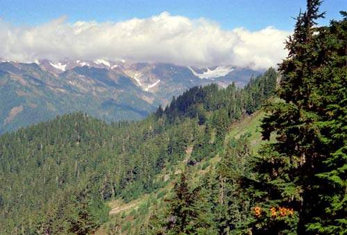
The trail continues past Three Lakes, and as it enters the south-facing wall of the valley, the trees grow larger. However, the continues to climb and as the trail passes above Reflection Lake, the trail once again opens into a more alpine landscape with small tarns and wildflower meadows. For the first time, great views of the southern Olympics appear above the North Fork Quinalt Valley. The trail tops out near 4000 feet, before dropping down to meet the Elip Creek Trail which descends to the North Fork Quinalt, 3500 feet below.
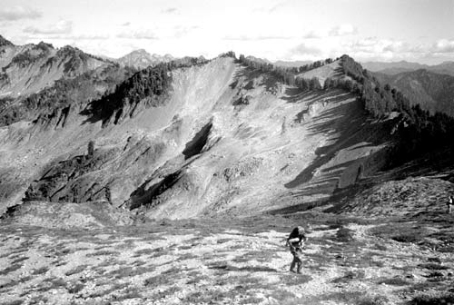
Beyond the Elip Creek Cutoff Trail, the path stays mostly level as it passes through open meadows and stands of small trees. The trail stays well below the apex of Tshletshy Ridge, allowing only views towards the east and building the desire to see what lies to the west and northwest (ie. Mt. Olympus). The trail passes through some great meadows at the headwall of the Three Prune Creek Drainage, with several nice campsites. A mile and a half past the trail junction, the path takes a more easterly course, climbing steadily to jump the ridge into the Stalding Creek Drainage and an broader view of the mountains to the north and east. The first views to the west, and the ridges leading to Olympus come as the trail passes around a small peak along the north wall of this canyon.
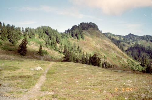
Kimta Peak
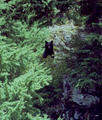
The ridge walking continues as the trail enters the Kimta Creek Drainage. Most of the trail is in sparsley forested areas so views abound. The area seems to have a high percentage of Black Bear. Our first spotting was a long distance view of a Bear and her cub in the Cirque above the South Fork Kimta Creek. During late summer, keep an eye out for Mountain Blueberry, which lines the trail and makes for easy snacking. I wanted to store up enough for blueberry pancakes in the morning, but could never hold onto a big enough stockpile.
The trail above the North Fork Kitma Creek affords beautiful views of Kimta Peak and to the ridge that will form the hike for the next four miles. The trail starts climbing as it moves towards Kimta Peak, offering the first views northward to Mt. Olympus. The climb to Kimta Peak was truly brutal, not necessarilly because it was overly difficult (it is rather steep in portions), but as you climb, you begin to notice the trail a mile or so ahead is almost 1000’ below you! Adding to the frustration is that it seems as though the trail really could have been kept level through this section.
Again, keep an eye out for bears along this portion trail, during our trip I nearly walked into a Black Bear taking part in the Blueberry Buffet along side the trail. Actually he was hiding on the opposite side of the bush, and my first realization that it was a bear was the sound of snapping twigs and seeing a large, round, black, rear of a bear high-tailing it up the hill. All he could do once he reached a prominenet perch was to look down at us and shake his head at me for disturbing his lunch.
Anyways, the trail eventually reaches the burned forest. During warm summer afternoons, the trail through here can get quite warm, but soon, the trail emerges into some more tree cover before starting it’s switchbacking to the ridge-top.
Lake Beauty
Once the trail reaches the ridge, the path breaks out into an open, treeless landscape that looks as though a glacier had just rolled through the day before, scouring off anything and everything in it’s path. The trail mostly becomes a scavenger hunt for the next rock cairn to guide you along your way. For the most part, the path stays pretty well marked with cairns, however we did lose them for a time being after crossing a stream and ascending up a steep hill. It took us roughly 20 minutes to relocate the trail and continue along our way, so as you pass through this area, make sure you have some patience and ample daylight. The trail would be nearly impossible in the twilight.
The trail eventually re-enters the woods, and emerges, after a small climb, on the Western side of the ridge, giving the hiker some good, easy walking. Trees mostly shield the views, but it is actually a nice change. The woods are shortlived however. The trail once again comes into an open scree slope, climbing in a couple of switchbacks back to the ridgeline. The views of Olympus here are amazing, and as you cimb, you notice a series of ponds and tarns leading down to the larger and impressively placed Lake Beauty. A side trail from the top of the ridge leads down to these exceptional camping sites.
Seattle Creek
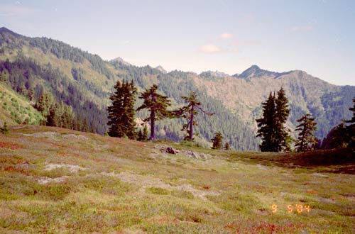
The trail continues down the the eastern face of the ridge, as it leads its way down to Seattle Creek, offering great views to the head of the valley towards Mt. Noyes and Mt. Seattle, as well as Mount Christie. The trail crosses Seattle Creek 3.25 miles past the ridgecrest. Skilled rockhoppers can generally make it across without getting wet, but it’s not a deep creek so even if you have to put in a leg, you won’t get too wet.
Beyond the creek crossing, the trail switchbacks steeply to the flanks of Mt. Seattle. Once the switchbacks end the scnenery is quite spectacular, offering impressive views of Mount Noyes, and towards the ridges to the west. As the trail rounds the southern ridge of Mt. Seattle, it begins to descend and impressive views of Mt. Christie and it’s glacier dominate the view. The trail crosses several small streams along its way (nothing too difficult) before paralleling the Quinalt River. The hiking stays easy all the way to Low Divide.
We headed back to the Irely Lake Trailhead viea the Quinalt River. However, from Low Divide, a hiker has many options for loop trips, or one way hikes across the entire park. Whichever route is continued, it would be hard to top much of the Skyline Trail.