Cone Peak
Low Point: 4240'
High Point: 5000'
Season: Summer/Fall
Difficulty: 0/5
Directions
Drive on Highway 20 heading east past Sweet Home, Oregon. In 36 miles you will come to Tombstone Pass. (This is approximately 13 miles west of Santiam Pass if you are coming from Central Oregon.) Watch for the parking area on the right, between milepost 63 and 64. Walk to the end of the parking lot beyond the bathroom to find the trailhead. (Northwest Forest Pass required)Trail Description
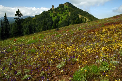
Cone Peak is located near the Santiam Pass along Highway 20 east of Sweet Home, Oregon (or west of Sisters, depending upon your perspective). It's a veritable wildflower cornucopia with over 300 species, along with some 17 tree species. I consider this to be REQUIRED visiting during the month of July while the wildflowers are in bloom, but you should expect a fair number of other visitors on weekends.
The first 0.6 mile is a gradual descent below Highway 20. You then cross the highway, and walk 50 feet to the left to pick up the main trail which heads up into the forest. The trail is well-graded with numerous switchbacks, passing by numerous different types of trees. At the 6th switchback you will catch your first glimpse of the wildflower meadows... keep going and your patience shall be amply rewarded! After several more switchbacks, you will find yourself in open meadows littered with penstemon, larkspur, paintbrush, stonecrop. Cone Peak will be directly ahead of you, with Iron Mountain to the west (left) and Echo Mountain to the right.
If you have time and energy, this trail can easily be extended into a loop that includes Iron Mountain. The length becomes 6.6 miles if you include the Iron Mountain summit, which stands at 5450 feet elevation.
To do the full loop, proceed on the trail through the wildflower meadows. You will walk downhill across a swale, and then angle left (west) toward Iron Mountain. The loop continues through forest, and then circles around the west side of Iron Mountain, with an optional 0.7 mile trudge to the lookout shelter at the top. If you are doing this hike on a weekend, expect this Iron Mountain summit spur trail to be packed with people of all ages.
Beyond that, it's a mile downhill through forest to Highway 20. Continue across Highway 20, walk downhill several hundred yards, and watch for the Santiam Wagon Road trail on your left. This climbs gradually for 0.3 mile back to the Tombstone Pass parking lot.