Citadel Pass/Lake Magog
High Point: 7850'
Season: Summer/Fall
Difficulty: 0/5
Directions
From the town of Banff, drive 9 kilometers west. Turn south onto Sunshine Road for another 9 kilometers to the large parking lot.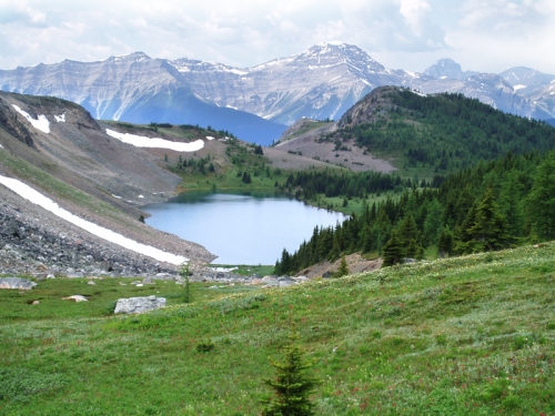
Trail Description
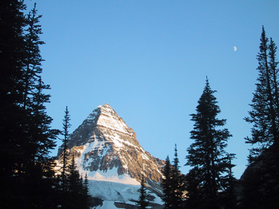
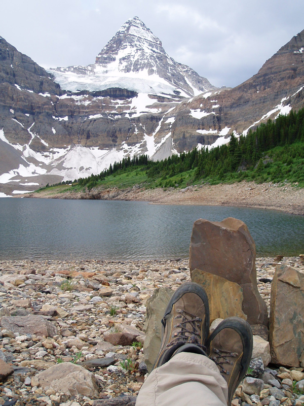
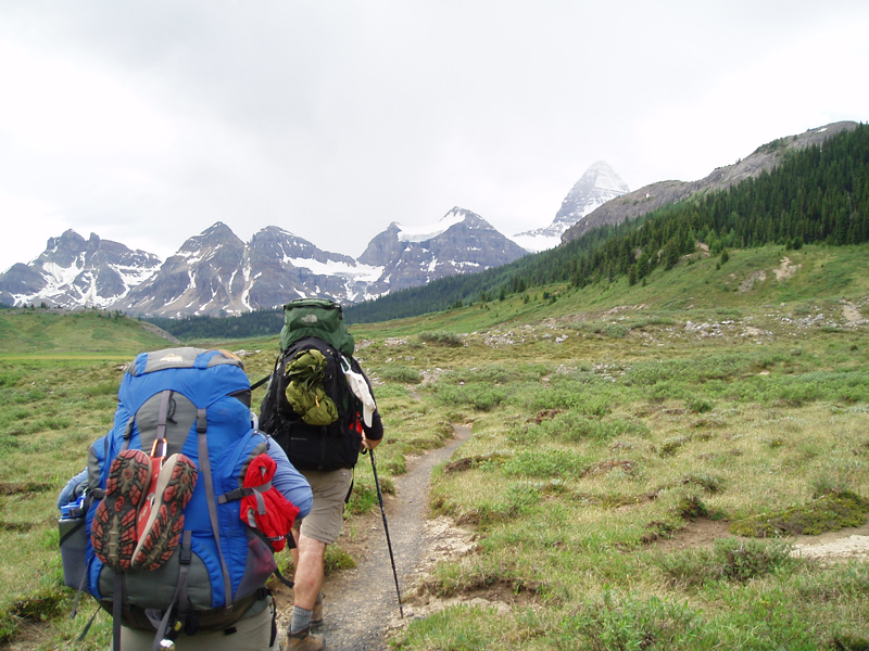
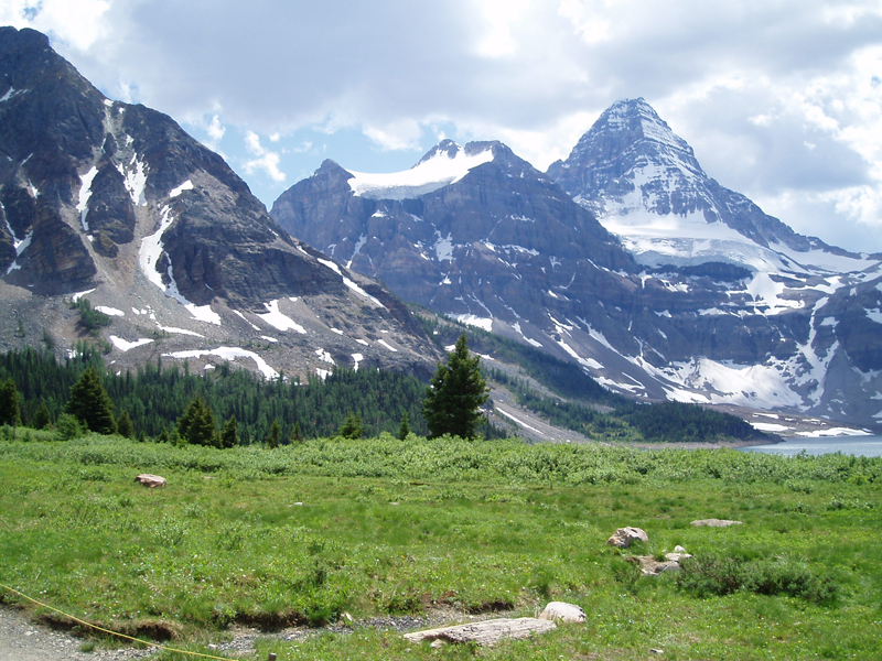
The Citadel Pass trail leads through vast meadows covered with vibrant Indian paintbrush, past craggy glacier carved peaks, and beside clear lakes reflecting the deep blue Canadian sky. At the end of this trail, lies one of the most spectacular mountains in the Canadian Rockies as well as a few niceties not normally found on a backpacking trip of this length.
Considerations for this trail:
This is Grizzly country. We didn’t see any, but did see quite a few tracks. I was nervous at the beginning of this trip since I have little experience hiking with the Grizzlies. I relaxed quite a bit as the trip progressed and really didn’t worry too much by the end. We did carry a bear bell, clapped and made noise in areas that had limited visibility, and carried bear spray (mainly just to make us feel better). The trip also requires you to do a fair bit of planning. Campgrounds in Banff are by reservation and you are required to purchase a backcountry pass. Campgrounds in Mt. Assiniboine Provincial Park are $5 CDN per person, per night (as of 7-9-06), and these are paid at the campground, so yes, you will have to carry cash with you.
The trail begins at the end of the Sunshine Village Road. Those really looking for a hike can trudge up the dusty road for three miles, or for $23 CDN (as of 7-9-06) you can purchase a round-trip shuttle bus pass at Sunshine Village, and effortlessly be delivered to the high alpine meadows (The latter option is definitely recommended). For more information and hours, call White Mountain Adventures (www.whitemountainadventures.com)
Upon leaving the upper portion of Sunshine Meadows Ski Area, the trail climbs steeply to the top of the ridge, splitting from the Rock Isle Trail at 1.2 km. Already, the spectacular views begin, as the path levels out and travels through the broad, view-packed alpine meadows. Views of Assiniboine rising above smaller peaks to the south, looking north reveals the peaks surrounding the Egypt Lake area, and to the west, the Monarch and Mount Shanks rise above deep valleys. The trail climbs to a great viewpoint before dropping to Howard Douglas Lake, a quaint lake surrounded by small trees. There are five campsites at the lake, complete with an outhouse, bear wire, and a cooking area. Since this campground is within Banff, it requires reservations.
Beyond the lake, the trail gradually climbs through the meadows to Citadel Pass, and the entrance to Mt. Assiniboine Provincial Park. Dropping gradually past Citadel Peak and numerous ponds, the trail hits a more severe grade 1.5 kilometers past the pass. The trail drops through a brushy hillside, giving great views of the Simpson River Valley and Simpson Ridge. We saw quite a few signs of bear in this area and since it was fairly brushy, we made sure to make a good deal of noise through this section.
Three-and-a-half kilometers from the pass, the trail splits, with a path leading to the valley bottom and Porcupine Camp (0.5 km from the intersection). To continue to Og Lake, catch the trail leading south as it breaks from the trees and traverses a steep wildflower-covered hillside. The trail along the traverse is pretty narrow and the combination of slippery rocks and spectacular views means extra care should be taken to avoid a rough fall down the steep, but grass covered hillside.
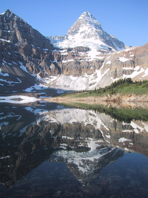
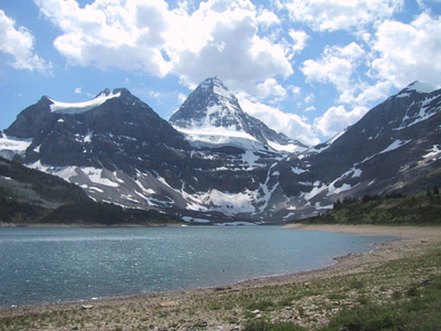
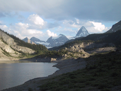
Two-and-a-half miles from the trail split the path meets up with the Simpson River Trail where it immediately starts climbing steeply up the tree-covered valley. As the trail grade mellows 1.5 kilometers from the junction, the path enters a terrain dominated less by trees, and more by open rock outcroppings, which on a hot day can be fairly unwelcome. Five kilometers from the Simpson River Junction, Assiniboine once again makes an appearance as the trail tops a rise and begins the descent to Og Lake (5.5 km from the junction). The Og Lake area is mostly scrub bushes and views up the valley towards Assiniboine and the smaller mountains clustered around it. There are several campsites at the lake, as well as bearwire, bear boxes, and an outhouse.
To finish off the trip to Magog, continue along the trail past Og Lake as it rises into a broad sweeping meadow. Five kilometers from Og Lake lies the first trail junction. The Magog Valley is really a maze of trails, but everything seemed to be well marked and easy to navigate. Hang a right at the junction, following this path for another 2 kilometers to the Lake Magog Campground. The campground has all of the features as the other campgrounds, but also includes water spigots. There were 25 campsites. The Naiset Cabins on the eastern shore of the lake are also offered to backpackers ($15 per night, per person – 7-10-06).
The Magog Valley has plenty of exploration possibilities, the Sunburst Valley, Cerulean and Sunshine Lakes, views from the Nublet or Og Mountain, the loop trail over Wonder Pass to Marvel Lake and Bryant Creek Valley. Another nice feature of the area is the Mt. Assiniboine Lodge. Teatime begins at 4:00, and they stock soda (coke and sprite) as well as a couple beers (Kokanee and “traditional”).
Upon completion of the trip, showers can be found in the town of Banff. We visited the YWCA. For $2.50 CDN, we were provided towels, shampoo, soap, and very clean facilities. To reach the YWCA, drive through the touristy portion of Banff along Banff Avenue, cross the Bow River at the south end of town. At the intersection, turn left; the YWCA is the first building on the left. There was also a nice little bistro that made for a convenient and pleasant lunch.