Goat Lake 2
Low Point: 4600'
High Point: 6600'
Season: Summer/Fall
Difficulty: 0/5
Directions
From Portland take I5 to US-12 exit (I think it was Exit 68) and head east towards Packwood. About 2.5 miles from Packwood, WA. Turn right on Forest Rd 21 (Also called Johnson Rd). At 15.6 miles after getting on the road you should see FR 2150 and signs for Chambers Lake. Go that way and park at the Snowgrass trailhead. A NW Forest Pass isn't required at Snowgrass per the Cowlitz Ranger Station but IS required at Berrypatch TH another 1/2 mile or so down the road. Berrypatch is a much bigger parking area with pit toilet. Snowgrass has none.Trail Description
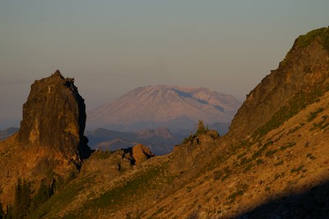
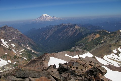
Early on the trail goes through forest. At 1-3/4 miles you cross Snowgrass Creek on a bridge and head left uphill. I went in early August and the mosquitoes were buggers. It climbs pretty good and you bump into Snowgrass Creek a couple of times. At 3.5 miles you come to a trail 97A which is a Bypass trail to the PCT. Continuing straight another 1/2 mile you come to Snowgrass Flats. I'd heard about Snowgrass Flats but found the area along the PCT to be much more profound in it's contrast and scenery. I'd camp along it. There are camping restrictions in Snowgrass Flats. At Snowgrass Flats, you switch from Trail 96 to 86 (Lily Basin Trail) to get to Goat Lake. If time permits though, first take a detour to the summit of Old Snowy Mountain (elev 7930). It's about a 4.5 mile roundtrip from the intersection of the PCT and Trail 96 (Snowgrass Flats Trail). You get great views of Rainier, Adams and the Goat Rocks. There's still snow along the immediate ridge and the hike up is full of wildflowers, snow, and volcanic rock. Great Alpine Country!
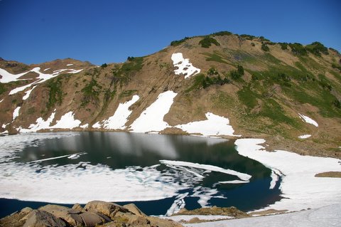
Goat Lake still had ice on it on August 6 and looked like it would all year. A few of us jumped in and it was COLD.
We camped just past Goat Lake. If you head back on the Goat Ridge trail as a loop, be prepared for little water. The last I encountered was about a mile past the intersection of Trail 86 (Lily Basin) with Trail 95 (Goat Ridge). I did not find the Goat Ridge Trail nearly as scenic as the Snowgrass Trail and if I had to do it over I'd reverse course after getting to Goat Lake. We saw elk in the valley and goats on the mountain. Overall I'd rate the trail as follows (1 Low and 5 High):
Scenery (4.0); Wildlife (3.0); Difficulty (3.5); Solitude (2.0 You can find it but need to hunt for it). The only downside was the mosquitoes and flies. That should clear up in late August though.