Fawn Lake
Low Point: 4850'
High Point: 5632'
Season: Summer/Fall
Difficulty: 0/5
Directions
From Highway 58, in the small town of Crescent Lake, turn south onto Forest Service Road 60. Follow this road for 2.2 miles, and turn right at the intersection, staying on Forest Service Road 60. Drive for 0.3 miles, turning left at a sign for the Fawn Lake Trailhead. Follow this road for 0.2 miles, turning right into the very large parking area. The trailhead is on the far western edge of the parking lot.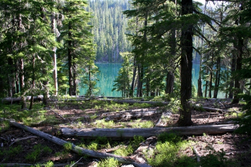
Trail Description
On the eastern edge of the Diamond Peak Wilderness, there are several quiet lakes inhabiting a landscape of lodgepole pines. Fawn Lake, the largest of these lakes is a great destination for a day hike, or a liesurely backpack. Those looking for a little more distance can continue to Stag Lake, where 7,066' Lakeview Mountain dominates the western edge of the lake. The Fawn Lake Trail can also be nicely combined with the Pretty Lake trail to form a nice loop.
From the trailhead, the path immediately crosses Forest Service Road 60, and then the Metolious-Windigo Trail before crossing into the Diamond Peak Wilderness. The walking is easy on the wide, open trail as it slightly climbs into denser trees. After a half mile, the trail reaches a fork, continue right towards Fawn Lake. The trail will begin climbing more steadily, with more and more firs and larger trees (some of them quite large) replacing the lodgepole pines. The trail soon turns west however, and the terrain flattens and the trees once again thin out with lodgepole pines dominating the landscape. The walking is great all the way to Fawn Lake, which is reached after 4 miles of hiking.
There are numerous good camping spots around the lake.
For those continuing to Stag Lake, turn right (north) at the trail intersection when you reach the lake, and continue around the north shore of the lake (ignoring a trail to the north which leads down to Odell Lake). Walk this trail for one mile, and then turn north at a trail intersection signed for Stag Lake, and hike this trail for a half mile. There weren't too many established camp sites at Stag Lake, but because the landscape is pretty flat, you can find nice places to set up a tent.