Eastern Oregon
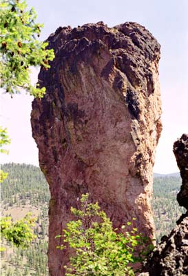
Steins Pillar
Length: 2 miles
Low Point: 4000'
High Point: 4500'
Season: All Year
Low Point: 4000'
High Point: 4500'
Season: All Year
Scenery: 3.2/5
Difficulty: 2/5
Difficulty: 2/5
Submitted by: Forrest
Directions
From Prineville, drive Highway 26 east for nine miles to Mill Creek Road, near the end of Prineville Reservoir. Continue on Mill Creek Rd. for five miles; turn onto road 500 for about 2.5 miles, and park in the turnoff at the trailhead.Trail Description
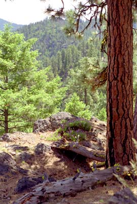
The Steins Pillar trail is very deceiving, offering views of the pillar only for the last half mile of the trail, but donsinglequotet expect a boring hike; the trail gives you plenty to look at all in a very short distance. The trail starts out meandering through a nice forest, but soon reaches open meadows that are covered with wildflowers during the spring. Many Cascade mountains and other green hills of the Ochoco Mountains can be seen from the open prairies. Eventually, the trail switchbacks down to the base of the tower, offering a very humbling view of the towering pinnacle.
Comments
Unless something has changed the trailhead is totally unsigned and doesn't necessarily look like a trailhead. I'd set the trip meter if you haven't been there before. I really like this hike. Although Steins Pillar is more photogenic from the road, this hike is a special close up look at its base. The cool thing is that, when you turn off on Road 500 you can't see the pillar and for much of the hike this is also the case. When the pillar shows up it is through the trees and you'd have to be looking for it. Then, all of a sudden, you pop out with this massive tower right in front of you. I say all this because I like to take people there, without telling them where we are going, and distract them with conversation at the points where they could see the pillar if they were looking. When they get to the pillar they are all the more taken aback. It's a cool place, and a drive to nearby Wildcat Campground can also be in order if you want to visit the Mill Creek Wilderness and Twin Peaks.
2005-07-30 15:32:43