Lost Coast
Season: All Year
Difficulty: 2.33/5
Directions
Hwy 101 South from Eureka. Follow the exit toward Ferndale and then toward Petrolia (this road is long and windy but quite spectacular). From Petrolia turn on the Mattole Lighthouse Road until you come to the trailhead and coast access. BLM office is off 101 in Arcata, just north of Eureka.Trail Description
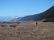
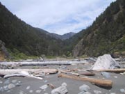
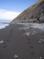
This hike is one of the best coast hikes I have done. I know it is in California but it is still an accessible drive from most of Oregon. It is one of the longest stretches of undeveloped coast left. It has a spectacular rocky coast with some black sand beaches, several creeks, all smashed between the ocean and the King Range. We did 4 days on the trail, and it is my favorite coast hike, even with a dislocated shoulder on the third day. We started at the Mattole Trail head and hikes south along the coast for two days to Miller Flat. From there we went up Kinsey Creek Ridge to the King Crest trail, and hiked back on that to the Spanish Ridge Trail, and then back down to the coast, and back to the Mattole on the coast. Water is plentiful on the coast with several creeks, but sparse on the ridge so a little planning is in order. The coast trial continues another 9 miles from Miller Flat to Shelter Cove for a total of 25 miles from Mattole River. Even longer hikes are possible if you continue south from shelter cove into the Sinkyone Wilderness State Park. The hike is in the King Range National Conservation Area, managed by the BLM. The BLM office is located in Arcata off of Hwy 101. Permits are required as are bear canisters during our trip so a stop at the BLM office is necessary when on the drive down. There are also portions of the coast that are impassible at high tide and a tide table should be picked up at a locale store or the BLM office. The bear canisters are available to rent for $5 at the Petrolia General Store, and the BLM office can provide you with more information. Weather can also be an issue on this hike. Cape Medecino is one of the wettest places on the west coast despite its dry appearance. We actually attempted this trial once in March and turned back after the first night because of a huge rainstorm. The second trip was in June though and the Weather was phenomenal. Good website with links regarding this area: http://www.sheltercove-lostcoast.com/lost_coast/